NTSB 'Altitude' Adjustments The FBI and NTSB have adopted a theory of mechanical malfunction as the cause of Flight 800's crash, while dismissing claims of an external source. However, eyewitnesses to the tragedy reported an object rise from the ocean surface and explode, moments before witnessing Flight 800's petrochemical explosion. Since these observations did not fit within the mechanical malfunction theory they were considered inaccurate. The investigating agencies stated that the eyewitnesses did not see an object rise from the ocean surface, but saw Flight 800 itself, climbing 1,500 feet from an altitude of 2.61 to 2.85 miles, after a spontaneous explosion in the plane's center wing tank. However, according to NTSB tract analysis[1] in exhibit22C (Main Wreckage Flight Path Study) of the Baltimore Hearings,the two 'data-fitting' scenarios upon which the tract simulationswere based each fall short of a 1,500 foot climb. The following quote was taken from exhibit 22C:
"…the radar data indicates that the aircraft turnedNorth of the pre-event course line. The radar hits and recoverylocation of the main wreckage provide constraints which were usedto add lateral motion to the simulation…
The radar primaries indicate a turn North followed by a turnto the South towards the main wreckage recovery site. Since thereare areas of uncertainty about all radar points and an absenceof altitude information, there are multiple solutions, which canfit the available data. Two approaches were explored. 1. A roll to the left followed by a right roll. 2. A left roll."
In case one, the NTSB simulations show a climb of 1,300 feet. In case two, 1,000 feet.
This discrepancy pales in comparison to an NTSB animation's[2]misrepresentation of the above tract analysis study. The viewpoint in this animation,taken from www.ntsb.gov, is severely restricted, making it impossible to gauge relative distances to the horizon. This view maymake a '1,500' foot climb appear higher than in a less restricted picture. And upon examination of the individual frames, it was found that an extra 2,000 feet was added to the climb, showing a climb of 3,400feet -- well beyond the limits of exhibit 22C's simulations andNTSB statements.
Two AltitudesClick on image to enlarge. 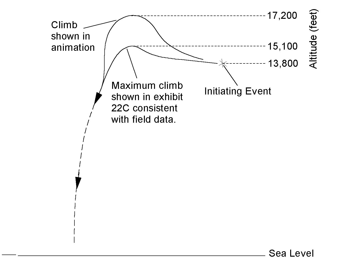
Figure 1: The above image shows two tracts of TWA Flight800. The lower tract is from Exhibit 22C data and the higher onewas shown in an NTSB animation.
Because many eyewitnesses reported seeing an object streakingupward from the ocean surface, an explanation of their observationswas established. The FBI alleged[3] that the eyewitnesses didnot see a separate object, but the plane itself, flyingafter the initiating event. It appears that the NTSB has followedsuit. However, as can be deduced above, a 1,300 foot climb from an altitude of13,800 feet is difficult to compare with an object rising fromthe ocean surface. Furthermore, the proposed climb would resultin just 1.5 degrees of angular displacement in altitude to observerson the beaches, ten miles away. In order to explain reported altitudedisplacements in excess of this amount, a more significant climbwas needed. Perhaps this need was accounted for by the additional2,000 feet in altitude and the restricted viewpoint in theNTSB animation. Dozens of eyewitnesses, not restricted by the limits of the NTSB animation, had a clear view of the horizon and the altitude at which Flight 800 was traveling. Many of whom[4-25] described the origin of the streaking object to be at the surface. To date, no simulationcan place the initiating event at this altitude within the mechanicalmalfunction theory.
Click on NTSB Animation Analysisfor the frame-by-frame analysis of the NTSB animation.
Click on The Original Animationfor the actual NTSB produced animation (1.6 MB).
- 1. Crider, D., Main Wreckage Flight Path Study, . 1997, NTSB:Washington, D.C.
- 2. NTSB, twa.beach.view.20.1.6.mov, . 1997, CNN: Washington,D.C.
- 3. Kallstrom, J., FBI Press Conference, . 1997, FBI: Washington,D.C.
- 4. Khalilch, R.G., Police Report, . 1996, Suffolk County PoliceDept.: Smith Point Beach.
- 5. Lenahan, F. and L. Lenahan, Police Report, . 1996, SuffolkCounty Police Dept.: Hampton Bays.
- 6. Lisle, B., Radio Interview, in Art Bell Show. 1998.
- 7. McConnell, S., Radio Interview, in Art Bell Show. 1998:East Moriches.
- 8. Naples, J., et al., Interview, in The New York Observer.1997: NY.
- 9. Penney, R., Taped Interview, . 1997, William Donaldson.
- 10. Runyan, P., Interview, in Daily News. 1996: NY.
- 11. Miron, D., Phone Interview, . 1997, Thomas Stalcup.
- 12. Terney, P., Police Report, . 1996, Suffolk County PoliceDept.: Mt. Sinai Harbor.
- 13. Verardi, C., Police Report, . 1996, Suffolk County PoliceDept.: Center Moriches.
- 14. Greig, M., Police Report, . 1996, Suffolk County PoliceDepartment: Mastic Beach.
- 15. Gallagher, W., Interview, in Press-Enterprise. 1997: Riverside.
- 16. Evans, E., Police Report, . 1996, Suffolk County PoliceDept.: In Boat.
- 17. Ellistion, B. and J. Gang, Police Report, . 1996, SuffolkCounty Police Dept.: Moriches.
- 18. Eick, D., Interview, in Press-Enterprise. 1997: Riverside.
- 19. Dougherty, T., Interview. Hard Copy, 1996.
- 20. Dorney, M., Interview, in The New York Observer. 1997:NY. p. 16.
- 21. Desyron, L., ABC World News Sunday, in ABC News. 1996.
- 22. Clanahan, Z., Phone Interview, . 1998, Thomas Stalcup.
- 23. Casola, L., Phone Interview, . 1998, Thomas Stalcup.
- 24. Casola, R., Phone Interview, . 1998, Thomas Stalcup.
- 25. Bilodeau, V. and J. McBride, Police Report, . 1996, SuffolkCounty Police Department: Moriches.
|
