| SEARCH Flight800.org: |
| FIRO: |
| About FIRO |
| Introduction |
| Petition |
| $DONATE |
| The Evidence: |
| Eyewitness |
| Radar |
| Forensic |
| Debris Field |
|
Black Box |
| Further Research: |
| In the News |
| Crash Simulations |
| Archived Articles |
|
Related
Sites |
| Newsletter: |
| FREE Subcription |
| Contacts: |
| Contact Washington |
| Tell a Friend |
4) Failure to explain or mention multiple high-speed (Mach 2) radar targets near the aircraft at the time of the accident. FACT: The McArthur/Islip Airport radar (ISP radar) was the FAA's closest radar site to Flight 800 when it exploded. For approximately 28 minutes up until Flight 800 lost electrical power, only a Navy P-3 Orion aircraft was tracked by the ISP radar in the airspace near where Flight 800 exploded and fell to the sea (see Figure 1).
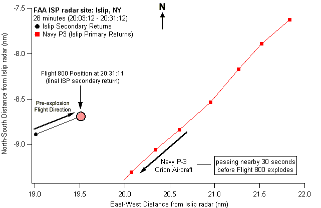 Figure 1: Twenty-eight minutes of radar coverage in the vicinity of Flight 800's crash site from the FAA radar site in Islip, NY prior to Flight 800 losing electrical power.
 Figure 2: Twenty-eight minutes of radar coverage in the vicinity of Flight 800's crash site from the FAA radar site in Islip, NY, plus five seconds of primary radar returns after Flight 800 lost electrical power.
FACT: Less than 4.3 seconds after a spontaneous midair explosion aboard Flight 800, a target appeared on radar approximately 1.5 nautical miles to the east of the explosion (Figure 2.). FACT: The target was recorded again on the following sweep (4.7 seconds after the first sweep) about 1/10 of a mile further to the southeast (see Figure 3 below). This position was consistent with where right-fuselage, center wing tank and forward cargo bay components were recovered, and was more than 1 nautical mile from where the main wreckage impacted the ocean.[3]
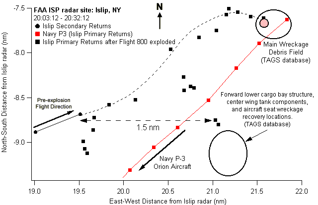 Figure 3: Twenty-eight minutes of radar coverage in the vicinity of the Flight 800 tragedy from the FAA radar site in Islip, NY, including one minute of primary radar returns after Flight 800 lost electrical power.
FACT: If the above mentioned target was wreckage that exited from Flight 800's airframe at any time after the loss of electrical power, its minimum average speed was approximately Mach 2 (twice the speed of sound). FACT: The North Truro, MA Air Route Surveillance Radar recorded a radar target approximately 1.7 nautical miles southeast of Flight 800 approximately five seconds after the loss of electrical power. The altitude of this target was 1,000 to 7,000 feet higher than the last known altitude of TWA Flight 800 (13,800 feet).[17] FACT: If the above mentioned target recorded by the North Truro radar was wreckage that exited from Flight 800's airframe at any time after the loss of electrical power, its minimum average speed was approximately Mach 2. See Figure 4 below.
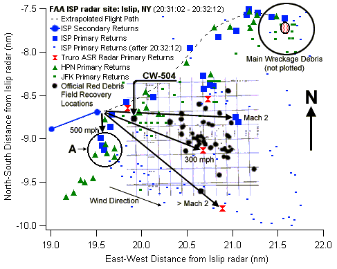 Figure 4: Radar coverage from four radar sites (ISP, HPN, JFK, N. Truro) superimposed onto official wreckage recovery data from the earliest (red) debris field.[3, 18] All speeds listed are averages; if from wreckage, initial exit velocities would have been higher. Recovery locations darkened for clarity.
FACT: Another radar target recorded by the North Truro radar 16 seconds after Flight 800 lost electrical power appeared 1.2 nautical miles ESE and within 3,700 feet in altitude of Flight 800 when it lost electrical power.[17] See Figure 4 above. FACT: If this last mentioned target was wreckage that exited from Flight 800's airframe at any time after the loss of electrical power, its minimum average speed was 300 mph. See Figure 4 above. FACT: Radar expert Michael O'Rourke, contracted by the FBI, concluded that "some portion or component of the aircraft kicked out to the right nearly immediately after the loss of the transponder signal."[19] See circled area (labeled A) in Figure 4. FACT: O'Rourke concluded that once the portion of the aircraft that kicked out to the right lost its momentum, "the parts associated with this debris descended to the ocean nearly vertically." See circled area (labeled A) in Figure 4. FACT: The official debris field database does not include any items recovered in the circled area (labeled A) in Figure 4. FACT: NTSB Exhibit 18 states: "There is still some significant missing structure in the key wing center section and fuselage red zone [early debris field] areas."[6] FACT: Wreckage item CW-504 is labeled in Figure 4. It was recovered so far west that the NTSB concluded that its recovery location "might even be in conflict with the proposed [crash] scenario."[6] FACT: According to O'Rourke's analysis, aircraft debris should have impacted the ocean approximately Ľ mile further west than CW-504, in the circled area (labeled A) in Figure 4. ASSESSMENT: Many radar targets from at least four separate radar sites indicate that wreckage exited the right side of the aircraft at high speeds. The NTSB has not discussed their appearance or implications. One NTSB report does suggest, however, that "some velocity could be imparted [to wreckage items] from the [initial] explosion."[20] But there is no indication that the NTSB ever attempted to determine if a fuel-air explosion (the official cause of the crash) could have imparted sufficient velocity to wreckage items to account for the radar data. ASSESSMENT: A very powerful force was needed to launch wreckage out the right side of the aircraft almost precisely when the aircraft lost electrical power. Some of this wreckage evidently landed in a debris field that was officially never located-a debris field that could have contained the "significant missing structure" that officials believe exited the plane early in the crash sequence.[Wildey, 1997 #91] But regardless of whether wreckage was officially located or not, the radar evidence is enough to call into question several key findings made by the NTSB. ASSESSMENT: The NTSB Final Report failed to identify any force within the official crash scenario that could have imparted the necessary energy to Flight 800 components to send them out the right side of the aircraft at the very high speeds indicated in the official radar record-a radar record substantiated by at least three independent radar sites (see Attachment II and Figure 4). ASSESSMENT: The NTSB has not adequately investigated the radar evidence or the types of explosions with which that evidence may be consistent. We urge the NTSB to address all of the radar returns discussed above and to propose a crash scenario that can account for their appearance. |